
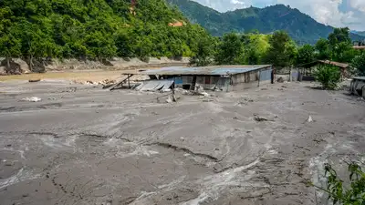
An area covered in mud and silt washed away by the devastating flash floods in Nepal. (PTI Photo)
The two ICIMOD reports, Changing Dynamics of Glaciers in the Hindu Kush Himalaya Region from 1990 to 2020 and HKH Glacier Outlook 2026: Insights from 50 Years of Himalayan Glacier Monitoring, provide a detailed assessment of glacier change across the region. HKH glaciers lost around 12% of their total area and 9% of their estimated ice reserves between 1990 and 2020, according to the reports. The Hindu Kush Himalaya contains the largest volume of ice outside the polar regions, with more than 63,700 glaciers covering nearly 55,782 square kilometres. ICIMOD said around 78% of the glacier area, located between 4,500 and 6,000 metres above sea level, is highly exposed to elevation-dependent warming. The reports identified the eastern Hengduan Shan mountains as the area with the highest percentage of glacier loss, with some areas losing up to 33% of their glacier area in three decades. The largest absolute losses, however, were concentrated in the Indus, Ganges and Brahmaputra basins, which contain more than 74% of the region’s glaciers.
So, as per current understanding, there is a detachment of the bedrock, which means that the bedrock from below the glacier is detached from its position and came down to the valley that created this disaster,” Azam said.
“This isn’t a distant problem; it’s a crisis unfolding in real-time, with new disasters every summer and monsoon,” Pema Gyamtsho, director General of ICIMOD, said. “The fact that ice loss rates have doubled this century should shock us all into action,” he added. “Between 1990 and 2020, HKH glaciers lost about 12% of their total area, but the losses are most acute for the region’s smallest glaciers—those below 0.5 km²—which are shrinking more rapidly than others,” Sudan Bikash Maharjan, remote sensing analyst at ICIMOD and lead author of the glacier dynamics report, said. Three-fourths of the region’s glaciers fall within this vulnerable size category, according to ICIMOD. Azam told PTI that debris from the ice-rock avalanche has accumulated at a river confluence, creating a temporary dam. “We are trying to navigate a rapidly changing future with an incomplete map,” Azam said in the ICIMOD report. Azam said that floods and glacial disasters occurring upstream do not recognise national boundaries. “In this particular case, we see that the disaster happened in the Nepal Himalaya and downstream, it immediately entered into the Tibetan boundary, where it hit the infrastructure there and then again it came down towards Nepal,” he said. “This is why we need to have a regional cooperation and data sharing policy to better understand these disasters and perhaps to be ready for such disasters in advance,” Azam added.
“This is basically an ice and rock avalanche. These glaciers feed at least ten major Asian river systems and support food, water, energy and livelihoods for billions of people downstream. The ICIMOD analysis found that the region’s smallest glaciers are shrinking more rapidly than others. He warned that the trend poses immediate risks of localised water shortages for high mountain communities and intensifies hazards such as glacial lake outburst floods. The immediate situation in Nepal has also highlighted another danger associated with debris and temporary lakes formed after major mountain disasters. Water is continuing to collect behind it, raising concerns about a possible secondary flash flood. “Without expanding our monitoring networks and standardising methodologies, accelerated changes in water flows and cryosphere risks could remain undetected until the impacts are severe. The Nepal-Tibet disaster has also underlined the cross-border nature of mountain hazards. Catch the latest World News and Live updates. Download the TOI app.
Released in March 2026, the reports found that glacier ice loss across the region had doubled since 2000, with the smallest and most vulnerable glaciers shrinking rapidly and intensifying hazards such as glacial lake outburst floods. It also revealed that glaciers have lost up to 27 metres of ice thickness since 1975 The warnings have come into sharp focus after a catastrophic flash flood triggered by a glacier collapse struck the Nepal-China border region this week, killing hundreds and leaving nearly 1,000 people missing. Its reservoir had held more than 2.5 million cubic metres of water, up from an estimated 1.5 million to 2 million cubic metres a day earlier, before overflowing into the Bhotekoshi River. The HKH Glacier Outlook 2026 synthesised data from 38 monitored glaciers and found that widespread glacier wastage had doubled after 2000. Of the 38 glaciers, only seven meet the global benchmark monitoring standards set by the World Glacier Monitoring Service. Earlier reporting noted: One of the two ICIMOD reports, the HKH Glacier Outlook 2026, which analysed data from 38 monitored glaciers, found that glacial wastage had doubled since the year 2000 in a strong indication that “parts of the Himalayan cryosphere may be nearing critical tipping points toward irreversible retreat. Earlier reporting noted: It, however, noted a data gap that only seven of those 38 monitored glaciers met the global benchmark monitoring standards of the World Glacier Monitoring Service (WGMS).
Nepal temporarily halted rescue operations, while Chinese rescue personnel and vehicles were moved to safer locations due to concerns over the dammed lake.
ICIMOD cryosphere specialist Mohd Farooq Azam told news agency PTI that the incident involved the detachment of bedrock from beneath a glacier, with ice and rock cascading down into the valley. It said regions with massive glacier presence including the Karakoram, Sikkim, Zanskar and Bhutan remained largely unmonitored. Earlier reporting noted: “It is related to climate change because the snow covers are reducing, the glaciers are receding, more rocky or barren areas are exposed – they absorb more heat which makes the slopes more vulnerable,” Mohd Farooq Azam, senior cryosphere specialist at ICIMOD and associate professor at the Indian Institute of Technology Indore, told news agency PTI on Thursday.
Researchers are investigating whether an ice-rock avalanche from a high-altitude location triggered the disaster. However, ICIMOD also highlighted significant gaps in monitoring. Major glacierised regions, including the Karakoram, Sikkim, Zanskar and Bhutan, remain largely unmonitored.
Months before the devastating floods struck Nepal and Tibet, two landmark reports by the International Centre for Integrated Mountain Development (ICIMOD) had warned that rapidly melting glaciers across the Hindu Kush Himalaya(HKH) were escalating the risks of catastrophic floods and other cryosphere-related disasters.
“This dam is collecting water, and it is expected that over the next three days, there will be more water collected in this temporary pond or lake,” he said. “So, there are chances that there may be some secondary flash flood in this valley. He added that the lake could also breach gradually without causing a flash flood.
The lake formed after the landslide began overflowing on Friday, prompting panic in areas already devastated by the floods.