
Warning for Bengal Hills
In Oct 2025, more than 300 mm of rain fell in parts of Darjeeling district in about 12 hours, triggering multiple shallow landslides and large debris slides, found the national landslide forecasting centre of GSI. An NRSC-ISRO assessment recorded 24 deaths across the affected region and widespread disruption of roads and settlements. Because a strong earthquake in such terrain can produce impacts well beyond shaking, the danger is compounded.
The event was initially reported as an earthquake, but the US Geological Survey later said the seismic signal was generated by the collapse of glacial rock and ice itself.
Kolkata: The glacier-collapse flood on the Nepal-Tibet border has put the spotlight back on a threat that is particularly relevant to Darjeeling and the wider Eastern Himalayas: an earthquake, rock or ice avalanche, extreme rain or the sudden failure of a glacial lake can set off a chain of landslides and flash floods capable of travelling far downstream, said experts. “Its vulnerability lies in its position within the same young, geologically unstable Himalayan system — with steep slopes, intense monsoon rainfall, and high seismic exposure,” a geologist said. The district’s own disaster management plan identifies earthquakes and landslides among its principal hazards and notes that the hill subdivisions repeatedly face landslides during the monsoon, said a senior Geological Survey of India (GSI) official. “Climate change is generating conditions that can destabilise high-mountain rock and ice,” Simon Cox, chief scientist at Earth Sciences New Zealand, told Reuters following the Nepal disaster.
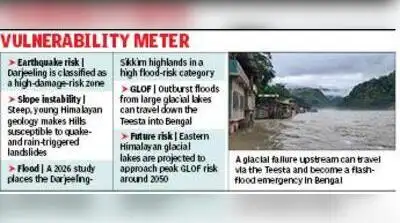
The Himalayan glacier collapse at Nepal and Tibet sent ice, rock and debris into the Lhende Khola river, unleashing a high-speed flood through valleys and settlements. The precise sequence that destabilised the slope is still being studied. For Darjeeling, the warning is significant even though the district itself does not contain the large high-altitude glacial lakes found in Sikkim. Darjeeling falls in Seismic Zone IV, the high-damage-risk category under India’s seismic zoning system. It can trigger rockfalls and landslides, weaken already rain-saturated slopes, block rivers and, in glaciated areas, send avalanches into lakes. A temporary landslide dam can create a lake that later bursts. Similarly, an avalanche plunging into an existing glacial lake can generate a wave large enough to breach its natural moraine dam. Scientists describe these as cascading or compound hazards. Warming can increase meltwater, degrade frozen ground, and alter freeze-thaw cycles, making some high-altitude slopes less stable. Darjeeling has already seen how quickly one hazard can lead to another.
A study published this month in the ‘Journal of Environmental Management’, analysing hydroclimatic conditions from 1951 to 2020, has also classified the Darjeeling-Sikkim highlands as a high-flood-risk zone. Modelling indicated that more than 10,000 people, around 1,900 settlements or structures, five bridges and two hydropower plants could face direct exposure in possible GLOF scenarios. The Oct 2023 outburst of South Lhonak Lake in North Sikkim sent a huge surge through the Teesta, washing away bridges, damaging NH-10 and the Chungthang hydropower project before the flood travelled downstream towards Bengal.
The GLOF threat becomes even more direct immediately north of Bengal. Bengal has already experienced the downstream consequences. The disaster caused extensive damage in Kalimpong district, demonstrating that a glacial failure hundreds of kilometres upstream can become a flash-flood emergency in the Bengal Himalayas.
You Can Also Check: Gold Rate in Kolkata | Silver Rate in Kolkata | Bank Holidays in Kolkata | Public Holidays in Kolkata | Kolkata AQI | Weather in Kolkata | Petrol Price in Kolkata | Diesel Price in Kolkata | CNG Price in Kolkata | LPG Price in Kolkata Stay updated with the latest Kolkata news.
The International Centre for Integrated Mountain Development has warned that the Eastern Himalayas could approach “peak GLOF risk” by around 2050 while overall GLOF risk across the Hindu Kush Himalaya could rise about three-fold by the end of the century. It also says large rock-and-ice avalanches are expected to become more frequent and larger as warming alters glaciers and permafrost. For Darjeeling, the danger may be a combination of earthquake-prone terrain, unstable slopes, extreme rainfall, river valleys, and an increasingly unstable cryosphere farther upstream. The Nepal tragedy underlines why disaster planning in the Eastern Himalayas can no longer treat earthquakes, landslides, GLOFs and flash floods as separate risks. Monitoring of glacial lakes and unstable mountain slopes, seismic-resistant construction, stricter development controls on vulnerable slopes and riverbanks, and river-basin-wide early warning systems extending from the high Himalayas to downstream Bengal are increasingly becoming part of the same preparedness challenge. Download the TOI App.