
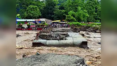
The committee is expected to submit its draft assessment and major policy directions within a year, said its chairman Eklavya Sharma. Darjeeling: Amid recurring floods in the region, Bengal govt has formed an expert committee to assess disaster risk in the Darjeeling hills, Terai and Dooars.
He also highlighted the potential impact of 12 dams — nine in Sikkim and three in Bengal — across the region. You Can Also Check: Gold Rate in Kolkata | Silver Rate in Kolkata | Bank Holidays in Kolkata | Public Holidays in Kolkata | Kolkata AQI | Weather in Kolkata | Petrol Price in Kolkata | Diesel Price in Kolkata | CNG Price in Kolkata | LPG Price in Kolkata Stay updated with the latest Kolkata news.
Emphasising north Bengal’s geographic position, downstream of major river systems like Teesta, Balason, Mahananda, Torsa and Mechi, Sharma said vulnerability mapping is crucial to preventing disasters, minimising loss of life and reducing property damage. The panel, set up by the urban affairs department, will combine local ground-level insights with a broader regional analysis to strengthen disaster preparedness and guide safe expansion of urban centres like Darjeeling, Kurseong and Kalimpong. The ground-level assessment will focus on identifying vulnerable settlements, unstable slopes, drainage issues and localised disaster-prone areas. Simultaneously, the broader landscape view will evaluate transboundary risks stemming from river systems, glaciers, dams and extreme weather events originating in neighbouring states and countries. In addition to disaster mitigation, the committee has been tasked with addressing urban saturation in hill towns, so new, geologically stable sites could be developed for expansion. The panel will also assess the economic and environmental impacts of tourism, which serves as a major driver for the local economy but imposes heavy demands on municipal resources. The committee’s first meeting is scheduled for mid-Oct. Download the TOI App.