
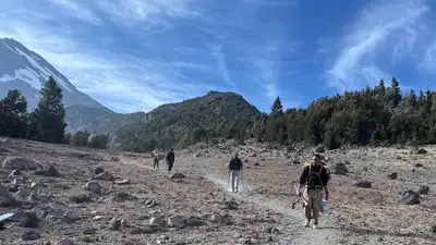
Hikers and rescuers make their way down Mount Shasta after the group became stranded during their descent. / Siskiyou County Sheriff’s Office
The three men left the Clear Creek Trailhead on Mount Shasta’s southeastern side on Saturday, August 29, and established a base camp at about 8,400 feet. At around 11,500 feet, one of the hikers fell and injured his knee. The group continued beyond the recommended turnaround time, descended after dark, lost its primary navigation method, went off route and had insufficient supplies for an unexpected night on the mountain.
According to the U.S. The Forest Service said one member also had a Garmin watch, although the group primarily relied on visual navigation during the descent. They said, “We relied too much on AI rather than our own critical thinking, according to the Forest Service account. The Siskiyou County Sheriff’s Office described the use of Gemini as a “critical misstep”, saying the hikers had been advised to bring far less food and water than their group required.
Forest Service and Siskiyou County Sheriff’s Office accounts, the group were novice climbers and had used several digital sources while preparing for the trip, including Google’s Gemini, YouTube and the AllTrails mapping application. Gemini was used for information about the route as well as decisions about what food and how much water to carry. About an hour after leaving the summit, the hikers contacted the Siskiyou County Sheriff’s Office dispatch for directions, but they eventually wandered off the established route and into the Mud Creek Canyon drainage. They had been using AllTrails for navigation, but the phone running the application ran out of battery and a backup charger failed. The group eventually stopped at about midnight in the steep drainage and spent the night there. They lacked enough food and water for an unexpected overnight stay and did not have adequate warm layers or emergency shelter. After the rescue, the hikers acknowledged that they had put too much faith in the technology. Officials stressed, however, that the rescue resulted from a combination of problems rather than a single AI-generated error. Authorities now advise climbers to contact the Mount Shasta Ranger Station before a trip, use established local information, carry multiple navigation methods including a paper map, regularly verify their position and prepare for an unplanned overnight stay. The sheriff’s office specifically advises climbers who have not reached the summit by noon to turn around.