
Weeks Bay quietly performs a lot of work along Alabama’s Gulf Coast that most tourists are unaware of. This little estuary near Fairhope, fed by the Fish River and the Magnolia River, filters waters before it reaches Mobile Bay, providing nursery grounds for prawns, oysters and the young of numerous fish species that eventually appear on dinner plates around the area. Understanding precisely how water and whatever it contains flows through that system is essential to maintaining its health, but the issue is a far more difficult subject than it may seem.
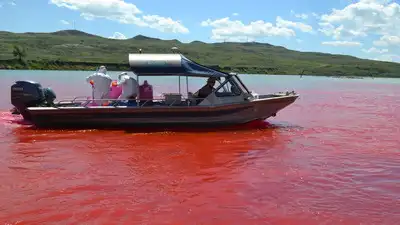
The Alabama Department of Environmental Management sought to answer that question with four days of research in the summer of 2024. The agency said it injected a bright red substance called Rhodamine dye at three sites along the river over four days, between July 29 and August 1, in addition to collecting streamflow and water quality data. The agency discharged the dye at three crossings on the Fish River at US Highway 90, Alabama Highway 104 and Baldwin County Road 32, then measured how long it took the colour to travel downstream towards Weeks Bay.
Because its mix of tidal marsh, wooded wetland and pitcher plant bog represents a broader slice of the Mobile Bay ecosystem worth preservation for long-term study, weeks Bay is a National Estuarine Research Reserve of NOAA, a classification it has had since 1986.
Despite its bright colour, ADEM said the dye is used in small amounts for time-of-travel studies. The dye is visible to the human eye, can be sampled in small quantities, and allows scientists to assess how swiftly water truly flows through a river system, not estimates based on the shape of the channel alone. Watersheds of this type border a national system of protected estuaries. Reserve staff currently collect water quality data from sites across the bay, and a well-calibrated model based on ADEM’s fieldwork might further improve those long-running records. A few days of fieldwork, a couple of Rhodamine injections and careful sampling yielded data that could influence how the Weeks Bay watershed is managed for years to come. Residents near the Fish River saw the dye study unfold in real time. For an estuary that supports shellfish and fish nurseries along the Gulf Coast, the temporary dye study could provide a clearer picture of how pollution travels through the water.

The larger goal behind the exercise was to gather the raw material needed to build and calibrate a water quality model of the entire Weeks Bay watershed, a computer-based tool that can simulate how pollutants spread through the Fish River, the Magnolia River and the bay itself under different conditions. Once the model is built, instead of responding solely when water quality concerns arise, authorities may be able to anticipate the likely impact of a planned construction, a new discharge permit or a spell of heavy rain.