
AMC has submitted a proposal to hire an consultant for the Local Area Plan
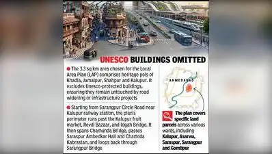
Ahmedabad: As Ahmedabad Municipal Corporation (AMC) works on a Local Area Plan for the 3.3 sq km around Kalupur railway station, it has submitted a proposal to the standing committee on the appointment of a consultant. An AMC official said, “For the development of any area in the city, a Town Planning (TP) scheme is formulated, which covers 100 hectares or more. Since Kalupur railway station is being developed, a Local Area Plan for the surrounding 3.3 sq km area is in the works which will involve micro-level planning. The official added, “Furthermore, there is a plan to frame new regulations regarding the redevelopment of buildings situated on privately owned land within this 3.3 sq km area around the station, aimed at making more land available for public spaces. In 2014, Ahmedabad’s Development Plan 2021 was approved, introducing the concept of Local Area Plans to Ahmedabad for the first time. Eight years ago, Ahmedabad Urban Development Authority (Auda) divided the metro and BRTS TOZ into 28 parts, prepared draft Local Area Plans for them, and submitted them to govt. The proposed Local Area Plans proposed over 58 parking plots near metro stations. Heritage to be untouched 1. The 3.3 sq km area chosen for the Local Area Plan comprises heritage pols of Khadia, Jamalpur, Shahpur and Kalupur.
It excludes Unesco-protected buildings in these areas, which means these will not be affected by road widening or infra projects The railway station is undergoing redevelopment and a station for the bullet train is being built on its premises. The railway station in Asarwa is also slated for development. Under the local area plan, roads connecting to the railway station will be widened, and new bridges or alternative routes will be planned to resolve traffic congestion. It includes basic road planning and reserves plots for public purposes. However, TP schemes are not prepared for small areas. New roads will be laid or existing ones will be widened to address traffic congestion. Planning will also focus on making land available for public utilities and determining what public infrastructure projects can be carried out in this designated zone in the future. The Local Area Plan is intended to enhance connectivity to Kalupur railway station and resolve traffic jams. In this plan, Transit-Oriented Zones (TOZ) were designated within a 200m belt on either side of the 37km metro route and the 98km BRTS route. Even after eight years, the plans have not been approved, as the state govt has returned them for modifications. Private roads within housing societies falling under the TOZs were also designated to be converted into public roads.
- It crosses Chamunda Bridge and passes by Saraspur Ambedkar Hall, Chartoda Kabrastan, and through Sarangpur Bridge back to Sarangpur Circle 3. The plan covers specific land parcels across various wards, including Kalupur, Asarwa, Saraspur, Sarangpur and Gomtipur You Can Also Check: Gold Rate in Ahmedabad | Silver Rate in Ahmedabad | Bank Holidays in Ahmedabad | Public Holidays in Ahmedabad | Ahmedabad AQI | Weather in Ahmedabad | Petrol Price in Ahmedabad | Diesel Price in Ahmedabad | CNG Price in Ahmedabad | LPG Price in Ahmedabad Stay updated with the latest Ahmedabad news.
The boundary of the Kalupur Local Area Plan runs from Sarangpur Circle Road near Kalupur railway station via Kalupur fruit market, Revdi Bazaar and Idgah Bridge. Download the TOI App.