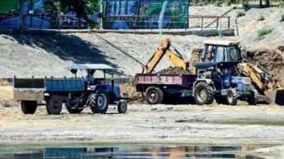
Desilting work underway at Puzhuthivakkam lake in the city
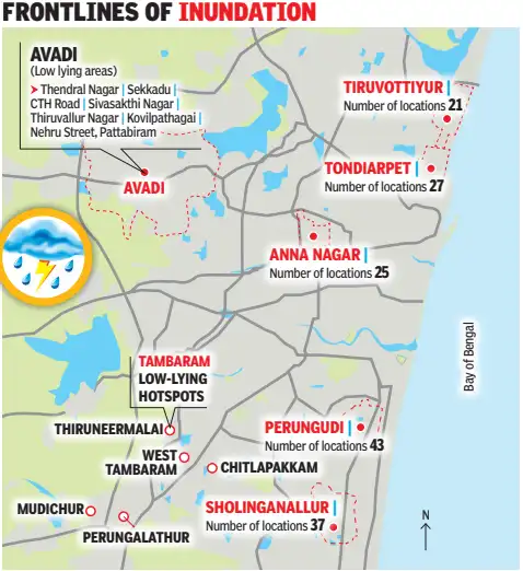
The study found that between 2000 and 2024, city’s built-up area grew 7.6%, vegetation cover declined 26.14% and water bodies shrank 22.54%. The researchers said rain in 2015 exceeded its estimated 100-year return-period intensity, while the 2023 event was associated with a nearly 25-year return period. Meanwhile, revenue administration and disaster management commissioner B Chandra Mohan said TN identified 1,030 locations with high or very high vulnerability and another 1,003 with moderate vulnerability. Between 2022 and 2025, 1,144.5km of stormwater drains had been laid, according to the corporation. OMR has the highest concentration of hotspots, with 43 in Perungudi zone and 37 in Sholinganallur. During the 2023 northeast monsoon, water levels exceeded three feet for several hours at 15 locations. These included Perambur subway, Ganeshpuram subway, MMDA Colony, 100 Feet Road near Arumbakkam metro station, Valluvar Kottam High Road and AGS Colony. This year, GCC and other civic agencies arranged 1,326 motor pumps to drain water. The city has 220 shelters and 111 kitchens ready. To prevent a repeat of the 2015 floods, the water resources department uses the Chennai Real-Time Flood Forecasting System and Real-Time Data Acquisition System to guide water release from reservoirs. The monitoring network is being expanded to include 117 rain gauges, 30 weather stations and 185 water-level recorders across reservoirs, rivers, canals and other waterways. Tambaram corporation has identified 32 vulnerable locations, with 15 shelters and nine kitchens ready. Preparedness (GCC) 1,326 Motor pumps ready, across four reported categories 311Boats on standby 220 Relief camps set up 110 Central kitchens ready Rain report Chennai: Annual rainfall –1,382.9mm Southwest monsoon (June to Sept) – 434.1mm Northeast monsoon- (Oct to Dec) – 867.4mm Tamil Nadu: Annual rainfall- 943.7mm Northeast monsoon – 447.4mm Southwest monsoon- 342mm You Can Also Check: Gold Rate in Chennai | Silver Rate in Chennai | Bank Holidays in Chennai | Public Holidays in Chennai | Chennai AQI | Weather in Chennai | Petrol Price in Chennai | Diesel Price in Chennai | CNG Price in Chennai | LPG Price in Chennai Stay updated with the latest Chennai news.
Greater Chennai Corporation 78,161 trees pruned 1,670 km of stormwater drains desilted 81 km of canals desilted Tambaram Corporation 32 vulnerable locations identified 897 km of drains desilted, including 344 km of stormwater drains 45 km of channels connecting lakes and waterbodies 15 shelters kept ready 15 areas flooded up to 5ft last year The city corporation will focus on 219 locations identified as flood-prone this northeast monsoon, down from 230 last year due to construction of more drains.
Rapid urban expansion, shrinking vegetation and waterbodies, drainage gaps, and low-lying terrain contribute to flood risk, according to a University of Madras study. “Spatial analysis show that flood-prone areas are concentrated in low-lying coastal zones, western and southern peri-urban areas, and Adyar River floodplain, where urban expansion, high flow accumulation, and historical flood occurrences overlap,” said first author Rahul Debnath. It has also got a response plan,” he said. Flood-prone hotspots will be monitored through the Integrated Command and Control Centre,” GCC commissioner G S Sameeran said. “Water releases are now regulated; they are timed ahead of heavy rain and coordinated with the tides at the river mouths, so that sudden flush releases like in 2015 are avoided,” Sameeran said. Commissioner R Saranya said there was no major flooding last Friday. We have kept heavy-duty pumps in the low-lying areas ready to tackle flooding,” she said.
The city’s flood-risk hotspots include Velachery, Pallavaram, Chromepet and surrounding southern localities, parts of western Chennai, Koyambedu, Villivakkam and areas around Tondiarpet. Frontlines of inundation The study found that roads and buildings replace permeable surfaces, reducing water absorption and increasing surface runoff. Drainage gaps in western and southern peripheral areas overlap with recent urban expansion, suggesting infrastructure has not kept pace with development. Areas more than 1km from mapped stormwater drains were classified as having drainage gaps. They recommend integrating land-use planning, terrain characteristics and historical flood records into flood-risk management. “Each location has a plan that is being used for mitigation. These plans include water-level triggers for action and evacuation, specifying where people should be moved as water rises. the GCC has expanded its stormwater drain network in recent years While the study identified gaps in drainage coverage. “We have deployed more heavy-duty motor pumps. “East Tambaram underpass was the only place that saw flooding, and it was cleared within a few hours. Download the TOI App.