
Satellite observations reveal that a glacier collapse instigated severe flash floods in the Rasuwa district of Nepal
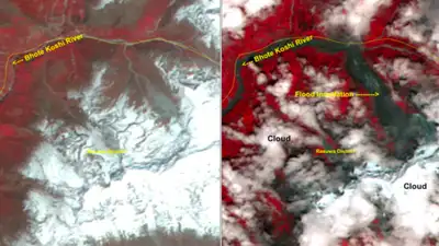
The post-disaster images were acquired by ISRO’s Resourcesat-2A AWiFS sensor on August 26, 2026, at around 10.30 am IST. HYDERABAD: A glacier collapse in the upstream Himalayan region appears to have triggered the massive flash floods that struck parts of Nepal’s Rasuwa district, with satellite images released by the National Remote Sensing Centre (NRSC) of ISRO showing the collapse zone, a swollen Bhote Koshi river and widespread inundation along the river corridor.
The post-disaster Landsat-9 image of August 26, 2026 marks the “zone of glacier breakage and collapse” in the high-altitude terrain upstream. The collapse sent a large mass of ice and debris downslope and downstream, followed by rapid melting and inundation, according to NRSC’s preliminary cause sequence. NRSC compared them with pre-event imagery to assess changes in the terrain and river system. The satellite assessment shows a major disturbance in the high-altitude glacier and mountain terrain upstream of the affected region. NRSC’s preliminary analysis traces the sequence to an ice-rock avalanche or landslide, followed by temporary blockage of the river and a sudden release of impounded water and debris. NRSC estimates that almost two-thirds of the glacier’s body detached and collapsed. The agency linked this sequence to the sudden flash flood and heavy debris surge along the Trishuli river system. River swells after collapse
Its preliminary cause sequence indicates that the glacier or ice-rock collapse may have blocked the river temporarily before the impounded water and debris were released downstream.
NRSC has specifically identified sections of the river as “swollen” and marked flood inundation extending beyond the normal channel into adjoining valley areas. A pre-disaster Sentinel-2 image dated August 24 identifies the same high-altitude zone as a glacier, while the August 26 post-disaster image marks the affected portion as an “ice rock avalanche”. The before-and-after images show a marked widening of the Bhote Koshi river after the event. The affected stretch lies in Rasuwa district near the Nepal-Tibet border, with Rasuwagadhi, Timure and the Trishuli river system among the locations shown in the satellite assessment. The post-event imagery also shows a broad disturbed tract descending from the glacier and ice-covered mountain terrain towards the drainage. Debris surge visible in satellite assessment NRSC described the event as a sudden flash flood accompanied by a heavy debris surge along the Trishuli river system. The satellite maps, however, do not quantify the total inundated area, volume of debris, discharge or damage to infrastructure. Cloud cover also obscures parts of the affected zone, limiting the extent of visible assessment.
You Can Also Check: Gold Rate in Hyderabad | Silver Rate in Hyderabad | Bank Holidays in Hyderabad | Public Holidays in Hyderabad | Hyderabad AQI | Weather in Hyderabad | Petrol Price in Hyderabad | Diesel Price in Hyderabad | CNG Price in Hyderabad | LPG Price in Hyderabad Stay updated with the latest Hyderabad news.
The post-disaster Landsat-9 image of August 26, 2026 marks the “zone of glacier breakage and collapse” in the high-altitude terrain upstream. The collapse sent a large mass of ice and debris downslope and downstream, followed by rapid melting and inundation, according to NRSC’s preliminary cause sequence. NRSC has cautioned that the findings are preliminary and that a detailed assessment will follow. The analysis was carried out by the National Remote Sensing Centre, ISRO, Department of Space. NRSC estimates that almost two-thirds of the glacier’s body detached and collapsed. The agency linked this sequence to the sudden flash flood and heavy debris surge along the Trishuli river system. Download the TOI App.