
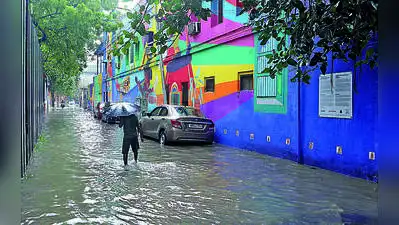
A waterlogged stretch of Deodhar Street
At 31.9 degrees, it was close to a notch below normal. In fact, the less heating due to the lower mercury was the reason for the milder thunderstorm activities in most areas on Friday. The maximum temperature fell below normal after a gap of four days. You Can Also Check: Gold Rate in Kolkata | Silver Rate in Kolkata | Bank Holidays in Kolkata | Public Holidays in Kolkata | Kolkata AQI | Weather in Kolkata | Petrol Price in Kolkata | Diesel Price in Kolkata | CNG Price in Kolkata | LPG Price in Kolkata
Alipore Met office recorded 33.6 mm of rain during the day while Salt Lake, which recorded over 60 mm rainfall on Thursday, logged around 11 mm on Friday.
Met officials said a trough running from Sikkim to North Bay of Bengal across Bangladesh is triggering the current spells of thundershowers. This system is expected to emerge over the Andaman Sea by late Friday night and influence the formation of a low pressure area by Saturday late evening or night. IMD officials reiterated that it was too premature to confirm the possibility of a cyclone forming over Bay of Bengal by next week.
Meanwhile, the upper-air cyclonic circulation over north Thailand that has propelled some private weather forecasters to predict a cyclonic storm over Bay of Bengal by around mid-next week continued to persist over the same region (north Thailand) on Friday.