
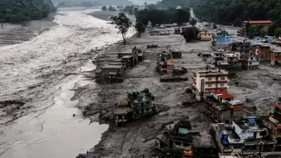
Once the initial flood had passed, debris left behind by the avalanche blocked river channels and allowed water to pool (Photo: Reuters).
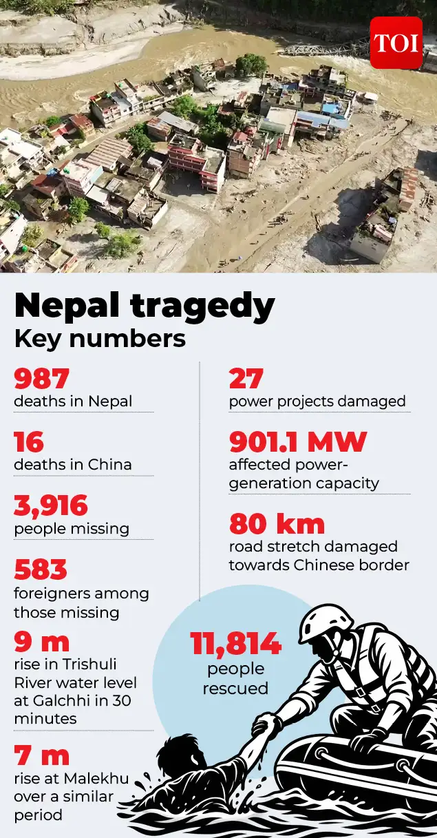
Nepal’s disaster agency said on Tuesday that 3,916 people remain missing, including 583 foreigners, while at least 11,814 people have been rescued so far, with emergency crews using helicopters and other aircraft to reach stranded communities where floodwaters and landslides have severed road links. China’s ministry of water resources measured the main dam on August 27 at roughly 150 metres long and 40 to 50 metres deep, holding between 1.5 and 2 million cubic metres of water, and warned that a further 3 million cubic metres, described as equivalent to around 1,200 Olympic swimming pools, could flow in over the following three days. By August 28 the lake had overflowed, forcing Nepal to halt helicopter rescue operations for 90 minutes as residents in Rasuwa ran to higher ground, Reuters reported. Satellite imagery on August 29 showed the lake shrinking to around 99,000 square metres, roughly the size of 14 football pitches, before China’s water ministry reported on August 30 that it had essentially drained through a natural channel. Chen Hongqi, a senior engineer at China’s Geological Disaster Technical Guidance Center, said at the time: “We estimate its area to be over 120,000 square metres, but its depth is currently unknown. A review of 1,267 documented landslide dam failures cited in the Science Media Centre’s briefing on the disaster found that 91.8 per cent fail simply by overtopping their banks, with no engineered spillway to control the release. Of those failures, 87 per cent occurred within a year of the dam forming, 71 per cent within a month, and 51 per cent within a single day. It was around 5,200 metres. The ice-rock avalanche moved with extraordinary speed, covering around 22 kilometres to Rasuwagadhi in just over seven minutes, according to a preliminary study by Nepalese scientists. The mass travelled at an estimated average speed of 46.3 metres per second, or about 167 kmph, as it plunged from the high Himalayas into the river system below, news agency PTI reported. The US Geological Survey had recorded a tremor of magnitude 5.2, not from an earthquake, but from the seismic energy generated by the collapsing ice mass itself. Water levels on the Trishuli River rose by as much as nine metres in 30 minutes at Galchhi and seven metres over a similar period at Malekhu. Nepal’s ministry of energy, water resources and irrigation later assessed damage to 27 power projects totalling 901.1 megawatts of capacity, including a fully destroyed substation, along with dozens of bridges and an 80km stretch of road to the Chinese border.
As experts consulted by the UK’s Science Media Centre put it, unlike an engineered reservoir, such a dam’s “geometry, internal structure and stability are therefore highly uncertain. Because at the bottom we have a rock, that cracked portion from the crack portion can slide, once inside those cracks, he said, the water works its way toward the base of the glacier: “When it reaches the bedrock,. That is mainly due to the increase in temperature.
Reported primary cause of the Nepal tragedy That single event set off a chain of destruction that has claimed almost a thousand lives, with a potential rise in numbers.
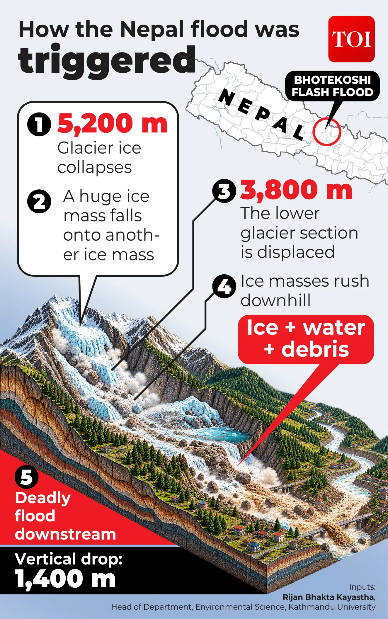
Initial reports hinted at the collapse of a “dam” or barrier, leading to the catastrophe. However, the flood that tore through Nepal’s Rasuwa district and across the border into Tibet on 26 August did not begin with a “barrier lake” bursting its banks. Chinese officials described the feature as an “impact crater” formed by the glacier fall. Speaking to TOI, Dr Rijan Bhakta Kayastha, head of the Department of Environmental Science at Kathmandu University, said the disaster’s origin lay entirely in the glacier itself. “The initial event on the 26, there was no involvement of lakes,” Kayastha said. A huge amount of ice fell, and it took another ice mass lying on the lower part of the same glacier, he said. “A part of the lower part of the glacier fell down from 5,200 metres to 3,800 metres, so the vertical height was 1,400 metres,” Kayastha said, describing the scale of the collapse. The barrier lakes that dominated the days of coverage that followed were a secondary phenomenon, according to Kayastha. “We can blame global warming , because nowadays temperature is increasing, and when we have higher temperature, more ice will melt at those altitudes also,” he said. “Last year also we had the same glacial flood on July 8, 2025, and before that we had one glacial lake flood in the Khumbu region near Namche, which happened on August 16, 2024,” he said. But we have to monitor, we have to visualise many, many satellites continuously,” he said, noting that crevices widen visibly before a collapse. “The only problem here in Nepal’s society is that one is the finance, the other one is, I think, the willingness or promptness, how seriously the political people take such issues,” he said. “If the river stops for a few minutes or a few hours, then they should be very careful about what happened upstream,” he said, adding that people should identify evacuation routes in advance. “There is a high chance of impact on Nepal’s economy, and yes, there will be fewer tourists,” he said, calling for clearer guidance on when travel in the Himalayas is safe. “Please avoid travelling during the monsoon period in the Himalayas mainly,” he said.
The catastrophic Nepal tragedy has now claimed more than a thousand lives while several still remain missing as rescue teams continue working to reach communities cut off by destroyed roads, bridges and landslides. The scale of the Nepal tragedy, explained in numbers. A barrier lake, in scientific terms, forms when landslide debris, ice or sediment suddenly blocks a river and holds water behind what is, in effect, an accidental dam. These features are notoriously unstable and short-lived. In the case of Nepal, once the initial flood had passed, debris left behind by the avalanche blocked river channels and allowed water to pool. However, the barrier lakes that formed downstream evolved rapidly and unpredictably in the days that followed. A second, larger body of water was also spotted by satellite immediately below the glacier-collapse scar, and unlike the first lake, it initially had no visible outlet, raising concerns that water pressure could keep building behind it. ” Barrier lakes of this kind are inherently short-lived. “Only glacier ice collapsed from high altitude. “Those two ice masses rushed down, converted to water and debris. We had a deadly flood downstream. There was another misconception that the floods were caused by an earthquake. This is the professor’s characterisation of the trigger; it is his explanation of the physical mechanism, based on his reading of what occurred, rather than a claim he presents as beyond dispute. Kayastha links the instability of the glacier itself to warming temperatures. Meltwater, he explained, finds its way into cracks in the glacier. “That meltwater goes and penetrates down, and there are a lot of crevices on that glacier. If we check the previous satellite images, we can see many cracks, meaning crevices. That was what happened on the 26th event. This is not, in Kayastha’s account, an isolated incident. “All three were during the monsoon period. In one or two weeks, if the temperature increases quite high, movement will occur, and such things may happen. ” Kayastha believes such events, though difficult to catch, are not beyond prediction. “It’s not impossible, it’s possible. The obstacles, in his view, are not technical. “We don’t have any technical and manpower or human resource issues. He also pointed to the practical risks people face during the monsoon, when rivers can be blocked upstream without warning. He expects consequences for Nepal’s tourism-dependent economy.
Released in March 2026, the reports found that glacier ice loss across the region had doubled since 2000, with the smallest and most vulnerable glaciers shrinking rapidly and intensifying hazards such as glacial lake Notably, Nepal was ranked the sixth most affected country in the world for 2024 by Germanwatch’s Climate Risk Index 2026, a measure of recorded deaths, people affected and economic losses from extreme weather that year.
He set out what an early-warning system should look like, i.e. satellite monitoring of glacier movement, combined with water-level sensors installed at two points downstream, “one upper site, one lower site”, so that a sudden rise can be flagged before a flood arrives. For remote terrain like the Langtang region, he suggested field cameras capable of monitoring from several kilometres away, watched around the clock. The Nepal tragedy is a reminder that in a warming Himalayas, disasters can unfold faster than warnings can reach people. Catch the latest World News and Live updates. Download the TOI app.
In fact, months before the devastating floods, two landmark reports by the International Centre for Integrated Mountain Development (ICIMOD) had warned that rapidly melting glaciers across the Hindu Kush Himalaya(HKH) were escalating the risks of catastrophic floods and other cryosphere-related disasters. For Nepal, the challenge now is to turn lessons from the catastrophe into better monitoring and quicker evacuation before the next glacier gives way.