
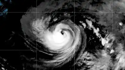
This satellite image shows Hurricane Karina strengthening off the southern tip of Baja California. (Photo: NOAA via AP)
A tropical disturbance in the eastern Pacific now has a 90% chance of becoming a tropical depression within 48 hours, while weather models cited by Southern California meteorologists show it could strengthen into a hurricane later this week before weakening and potentially moving towards the region.
An unnamed storm struck near Long Beach in 1939, while Hurricane Nora entered California as a tropical storm in 1997 after first making landfall in Mexico, according to the NWS. “Most recently, Hilary brought significant rainfall and impacts to Southern California in August 2023. Citing NWS data, it reported sea surface temperatures across Southern California at 5 to 10 degrees above normal for the time of year, with readings of 74 to 76 degrees along Los Angeles County beaches. The National Oceanic and Atmospheric Administration (NOAA) has tracked a marine heat wave off central and Southern California since May 2025, before the present El Niño developed.
The NHC’s final analysis found that Hilary lost its tropical characteristics over northern Baja California and became post-tropical before moving into Southern California.
“However, several tropical systems have weakened below tropical storm strength before making landfall,” Lewis said. KTLA linked the potential storm to a “super” El Niño brewing in the Pacific and noted that the climate pattern is associated with warmer waters in the eastern Pacific. NOAA says more recent warming off Southern California may increasingly reflect El Niño’s influence.
Direct tropical-storm landfalls from the Pacific are rare in California. Hilary was not a tropical storm by the time it reached California. Despite weakening, it brought significant rainfall and flooding to the region. The relationship between El Niño and the current marine heat wave is more nuanced, however.
An earlier NHC outlook had put the 48-hour formation chance at 80% and the seven-day probability at 90%, figures cited by National Weather Service (NWS) meteorologist Bryan Lewis. The centre later raised the shorter-term probability to 90%.
Kaj Goldberg, a meteorologist with KTLA, a Los Angeles television station, said forecasters were closely watching the disturbance. The station said weather prediction models showed a strong possibility of an eye developing off Baja California by Thursday, although the NHC has not forecast an eye forming at this stage. “This is the disturbance that, if it does form and come together, could make its way right into Southern California about one week from today,” Goldberg said.