
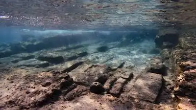
Divers have mapped 25 mysterious manmade structures on the seabed off Cromer, Norfolk, at the site linked to medieval Shipden. (Photo: Getty Images)
Divers investigating the remains of Shipden, a settlement off the coast of Cromer in Norfolk, have photographed and mapped 25 manmade features on the seabed, according to Popular Mechanics. The Domesday Book of 1086 recorded 117 residents, three acres of meadow, 36 swine, a harbour, manor houses and two churches. Historical records indicate that the church was damaged by the sea in 1317 and was underwater by about 1400. Sea levels reached particularly high levels around 1380, and by 1400 St. The mystery surrounding the underwater remains was further complicated in 1888, when the Great Yarmouth steam paddle tug Victoria struck a submerged obstruction while carrying passengers on an excursion to Cromer.
That visible remnant may have helped keep memories of the lost settlement alive.
The North Norfolk District Council has described Shipden as a “forgotten parish” swallowed by the sea and compared it with Norfolk’s own version of Atlantis. The church’s bell could even be heard tolling beneath the waves, according to the local legend. Peter Stibbons, chairman of the Friends of Cromer Museum and a director of the project, told the BBC that the discovery represents a significant challenge to a story generations of Cromer residents grew up hearing.
A medieval village that disappeared beneath the North Sea centuries ago is giving up new clues, but the most important piece of the puzzle remains missing. Researchers are now trying to determine whether the underwater structures can finally establish the location of St. Peter’s Church, a building long associated with the vanished village. The search is also challenging a centuries-old local belief about a rocky formation known as Church Rock. Shipden was once a thriving medieval coastal settlement. The coastline looked very different at the time. Land that now lies beneath the North Sea once extended beyond the present-day cliffs around Cromer. Over several centuries, erosion, flooding, rising sea levels and powerful storms gradually consumed the settlement. Shipden was associated with two settlements: Shipden-juxta-Mare, meaning Shipden by the sea, and Shipden-juxta-Felbrigg. St. Peter’s Church belonged to the coastal settlement. For centuries, local fishermen believed a formation known as Church Rock was actually the remains of St. Peter’s Church tower. But researchers now believe that story may have been wrong. Recent seabed surveys suggest the church could have stood northwest of the traditional Church Rock location. That possibility means the flint formation long identified by local people as the church may instead be an unrelated underwater structure. Researchers are currently comparing medieval documents with the physical evidence found underwater. Stibbons cautioned that the team is developing possible interpretations rather than presenting definitive conclusions. The disappearance of Shipden was not necessarily the result of one dramatic event. Historical evidence points to a combination of rising sea levels, severe storms, flooding and long-term coastal erosion. Peter’s Church had reportedly been submerged. Yet the church tower remained visible during very low tides for centuries, reportedly continuing into the 1800s. The vessel became stuck, but everyone aboard was rescued by smaller boats. The obstruction was later destroyed using explosives. Researchers now believe that event could help explain some of the disturbed or toppled flintwork discovered by modern divers. It may also have influenced later local interpretations of what lay beneath the water.
The 25 mapped features provide new evidence of human activity in an area that is now completely underwater. For now, Shipden remains one of England’s most intriguing lost settlements, a place where archaeology is slowly testing the boundary between historical fact and centuries-old coastal legend. The investigation is part of the Alfred Savin Project, run by the Friends of Cromer Museum. Its objective extends beyond finding St. Peter’s Church. Researchers are studying how Cromer’s coastline changed over geological and historical timescales and how those changes affected settlements. Among the discoveries is a flint wall that may have been part of a medieval sea-defence structure, although researchers say further investigation is needed to establish its original purpose. The latest diving season has ended, with material and documentation collected during the investigation being taken to Cromer Museum for further examination. The precise location of St. Peter’s Church remains unresolved. For the researchers, however, finding the church is only part of the story. Each piece of masonry, historical document and seabed feature could help reconstruct a medieval landscape that disappeared beneath the North Sea. You use AI every day. Now get your AI Quotient. Take the AIQ test.