
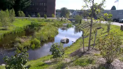
The transformation, known as Mill Brook Crossing, was officially completed with a ribbon-cutting ceremony on September 16. For decades, a stretch of Mill Brook in Athol, Massachusetts, was hidden beneath asphalt, largely out of sight beneath what had become a downtown parking area. This month, the small central Massachusetts town celebrated a very different landscape: the stream is flowing in the open again, new wetlands surround it and much of the former pavement has been replaced with greenery. Reporting by Streetsblog Massachusetts and the Athol Daily News, along with information from the Massachusetts government, shows how the project turned a heavily paved commercial area into a greener public space designed to address flooding, extreme heat and pedestrian safety.
The site was formerly known as Lord Pond Plaza, a large commercial area where Mill Brook had been confined underground in a culvert. The idea of bringing the stream back into the open emerged through Athol’s climate resilience planning. Massachusetts state documents say the project was designed to improve stream connectivity while addressing the area’s vulnerability to flooding and excessive heat. The town had identified the plaza as an urban heat island, with the large expanse of asphalt contributing to higher temperatures in the surrounding downtown area.
Massachusetts’ Complete Streets program provided nearly $250,000 for sidewalk improvements connected with the project. The former plaza presented another problem beyond its environmental impact. The redesigned space introduces a more organised layout along with new sidewalks and pedestrian infrastructure. From parking space to climate-resilient public space What once largely functioned as a sea of asphalt is now a landscape built around a visible stream, wetlands, trees and other green infrastructure. For Athol, the project represents a shift in how a downtown space can be used: rather than treating the buried waterway and surrounding pavement simply as infrastructure, the town has brought part of the natural landscape back into view while creating a public area intended to better handle heat and stormwater. The result is a downtown setting where a stream that spent decades underground once again forms part of the town’s visible landscape.
The large, open parking area had complicated vehicle and pedestrian movement, with town planning documents previously identifying concerns around traffic circulation and pedestrian safety.